Notes on an old Slide Collection IV: Wreck at Canyon

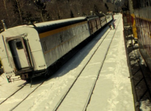
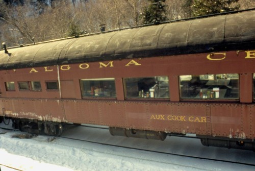
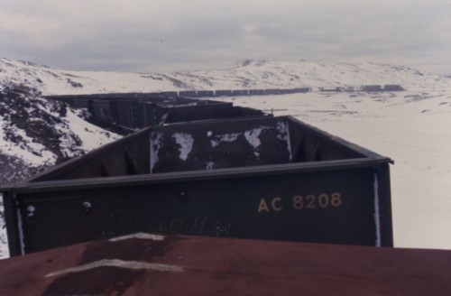
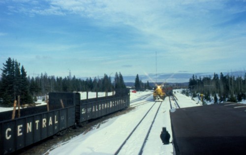
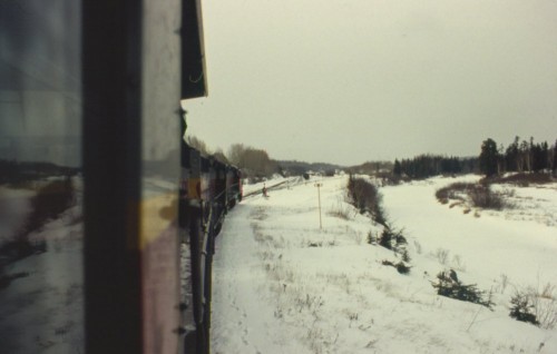
Here’s an interesting sequence of images taken by a photographer riding in the cab of the trailing unit of northbound freight train No. 9 from Steelton Yard (Sault Ste. Marie) to Hawk Junction. As the train arrives at the north end of Canyon siding we see several cars of a work train parked in the siding and house track at Canyon. The siding has a string of gondolas and flatcars which be loaded with ties, track parts and other maintenance materiel. The farthest gondolas may be crane support cars. In the house track is a string of crew accomodation cars.

scan0043 scan0044 scan0046scan0045

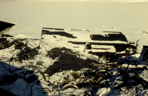
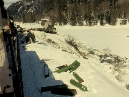
The reason for the railway service cars becomes quite clear as we encounter the mangled remains of several wrecked hopper cars. A recent wreck at the north switch of the Canyon siding has spilled several cars and their contents of sintered iron ore down the embankment and into the Agawa River alongside the tracks.

scan0029scan0042scan0041

We can see that crews are quite busy cutting up many of the damaged cars for scrap on the spot. There’s not much left of this hopper car, and look at that pile of acetylene bottles:

scan0040

Several cues have already led me to date the slides in this collection to a trip made sometime during the winter of 1980-81. Ted Ellis also has a pair of photos of a similar wreck at the north end of Canyon siding on his website:

http://algomacentral.railfan.net/images/AlgoCenRy/AC_Canyon_wrk-1_3-9-1981.jpg

http://algomacentral.railfan.net/images/AlgoCenRy/AC_Canyon_wrk-2_3-9-1981.jpg

These photos are dated March 9, 1981. I think it’s pretty safe to say we are looking at the results of the same wreck, with the slides in my collection having been taken several days to a couple of weeks after Ted’s photos, which appear to show the beginnings of the wreck cleanup to re-open the line. Aside from providing an interesting angle of a few wrecked cars, these wreck shots pretty conclusively date this set of slides to March of 1981.

And to tie things off, here’s a neat sequence of images of a southbound work train carrying the ruined remains of those wrecked cars on their last trip by rail, on April 1, 1981:

http://algomacentral.railfan.net/images/AlgoCenRy/AC_166T_Sault-4-1-1981.jpg

http://algomacentral.railfan.net/images/AlgoCenRy/AC_166T-2_Sault-4-1-1981.jpg

http://algomacentral.railfan.net/images/AlgoCenRy/AC_166T-3_Sault-4-1-1981.jpg

Notes on an old Slide Collection III: Michipicoten Branch

A few more from the collection. This batch is all related to the Michipicoten subdivision branchline west of Hawk Junction.

The Michipicoten branch runs 26 miles from Hawk Junction west to Wawa and the harbour on Lake Superior at Michipicoten. Primarily serving the Algoma Ore Properties (a subsidiary of Algoma Steel) iron mines and sinter plant at Wawa, this line was the domain of the ore trains.

scan0010

East of Wawa, winter 1980-81. Photographer unknown. Chris vanderHeide collection.

An empty ore train westbound between Hawk Junction and Wawa. East of Wawa there is a significant area where the landscape has been ravaged by the fallout of nearly a century of iron ore processing in the area. Those familiar with north-central Ontario will be aware of the similar treeless blackened landscape that made the Sudbury region [in]famous before INCO built the “super-stack” there to disperse (and thereby dilute) emissions over a larger area, and a concerted environmental remediation program was undertaken.

Here we see the ore train snaking through the rocky terrain of the treeless zone. The winter contrast of white snow against the black rocks only increases the starkness of the scene. I guess on the plus side, you get a pretty good view of the entire train, which isn’t very common on the remote lines twisting their way through the northern Ontario forests.

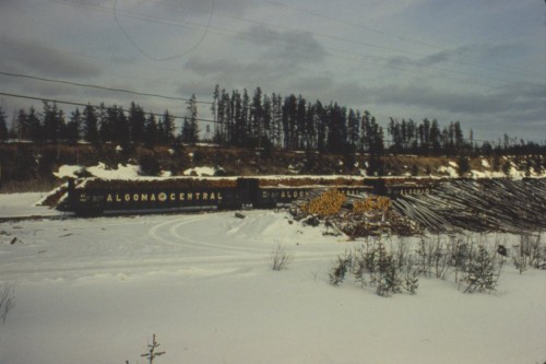
Look closely and note in particular the first four cars of the train – not ore hoppers but empty flatcars and a gondola for pulpwood loading at a log spur west of Wawa.

This location can be deduced to be Trembley, a siding approximately 3-4 miles west of Wawa. The timetable additionally lists two loading spurs at Trembley, one operated by Abitibi Paper (later St. Marys Paper) and the other by Newaygo Forest Products (a company that also had significant operations at Mosher and Mead on the Northern Subdivision).

Close inspection of the photo shows one of the spurs curving off far in the background to the left of the engines of the train. Based on the sequence of slides in this batch, and also comparing the layout to the traces left behind and visible on overhead satellite imagery, this photo is taken at the east end of Trembley siding from the caboose of the same train as the ore train seen above. The train is westbound to Michipicoten harbour and standing on the main track at Trembley. The engines visible in this photo are NOT from the same train however. Close inspection of both photos shows a pair of SD40 type locomotives on the head of the ore train, and there are at least 3 GP7 locomotives on the pulpwood extra seen here. (Note that timetables through the 1970s and ’80s did not list any regular trains on the branch, and all trains were run as extras.)

While the above photo at first glance may appear to show an arriving train pulling into the siding, there are a number of things that don’t make sense about that, not the least of which is that it appears to be showing a *loaded* train of pulpwood arriving from the east, and pulpwood loads should be heading back in that direction. Clearly this train was likely already here and waiting in the siding for the arrival of “our” train and has resumed actively switching the Abitibi spur in the distance, while our train has stopped on the main track to set off those 4 empty cars for pulpwood loading seen at the front of the train in the first photograph.

The branch is mostly known for the ore related traffic, and solid trains of hoppers, but this photo really shows the scale of pulpwood operations here; clearly there was enough traffic to be running both a pulpwood extra and an ore extra (which also had 4 more empty cars to drop off for pulpwood loading!) The 1978 Time Table lists car capacities of the Abitibi and Newaygo spurs at Trembley at 45 and 24 cars, respectively (at 50′ per car), and in addition to the 44 car passing siding, instead of a car capacity in the house track column is the notation “Yard”, suggesting the presence of perhaps two or more side tracks for car storage in addition to the identified customer spurs. This definitely expands the operational possibilities on the branch line, and for pulpwood loads in general.

scan0024

Wawa, winter 1980-81. Photographer unknown. Chris vanderHeide collection.

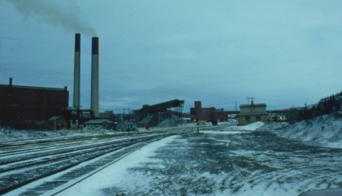
Wawa. The primary raison d’être of the Michipicoten branch of the Algoma Central Railway was to serve the iron mining of the Wawa area. The mining industry in the area has had a rocky history, with various operations stopping and re-starting in the early part of the 20th century.

From its incorporation in 1899, the Algoma Central was built to move iron ore from a large deposit discovered near Wawa to a harbour built at Michipicoten Bay on Lake Superior. The harbour featured a elaborate wooden ore dock and a commercial dock where passenger boats called and other ships loaded pulpwood. Ore and pulpwood was shipped south over the lake to the various industrial interests in Sault Ste. Marie. The ACR also (slowly) pushed north from Sault Ste. Marie but the 1903 financial crash of the industrial empire of which the ACR was a part brought things to a halt with construction not beginning again until 1909. It was only in 1912 that the main line reached what is now Hawk Junction and connected Wawa to the Sault directly.

The first iron ore sintering plant at Wawa was built in 1939, and was significantly expanded several times over the next 50 years. By the 1980s, ore from the MacLeod Mine (a 2000 foot deep underground mine located adjacent to the site of the original 1899 Helen open pit mine) was delivered directly to the sinter plant via the world’s tallest single-lift conveyor belt. Here the ore was heated and blended with additives such as limestone and other ore fines brought in through the harbour at Michipicoten to upgrade the ore for the Algoma Steel blast furnaces at Sault Ste. Marie. In 1998 however, the Algoma Ore operations around Wawa were shut down, with the steel mill sourcing taconite ores from south of the border, and the sinter plant was eventually torn down. Absolutely nothing in the above photo save for the rocky terrain itself still exists today.

scan0021

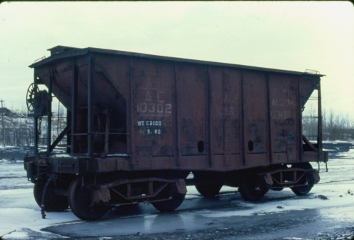
AC scale test car 10302. Wawa, winter 1980-81. Photographer unknown. Chris vanderHeide collection.

This scale test car photographed at Wawa was converted from one of the first steel hopper cars rostered by the Algoma Central. These cars were built by the Pressed Steel Car Company in 1900-1901, meaning this car was somewhere around its 80th birthday when photographed in the winter of 1980-81. Amazingly this car actually still exists today; it’s preserved at the Canadian Railway Museum in Delson, Quebec.

scan0023

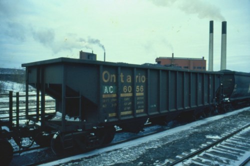
AC hopper 6056 (ex-ONT). Wawa, winter 1980-81. Photographer unknown. Chris vanderHeide collection.

From the oldest to the newest. Built in 1971 by National Steel Car for the Ontario Northland Railway, these are actually older than the 8201-8500 series rapid-discharge cars acquired new in 1974-75, but these 30 cars acquired secondhand from the ONR in 1978 were the last hoppers acquired by the Algoma Central Railway before they were absorbed by the Wisconsin Central in 1995. For several years they kept their old Ontario Northland numbers with the reporting marks re-stencilled “AC”, but around 1986 these cars were renumbered into a proper AC number series, AC 8600-8629. A check of the UMLER (computerized equipment register) shows that many of these cars are actually still in service, making them the last surviving hopper cars in AC markings.

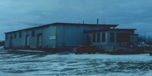
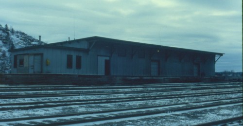
scan0025

Wawa, winter 1980-81. Photographer unknown. Chris vanderHeide collection.

scan0026

Wawa, winter 1980-81. Photographer unknown. Chris vanderHeide collection.

Express freight shed at Wawa. Front and back sides. This is pure gold for being able to model this structure. While much larger, some similarities in construction can be seen between the Wawa shed and the smaller shed at Hawk Junction, seen in the previous post.

scan0022

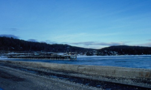
And finally, on the frozen shores of Lake Superior at Michipicoten harbour. This photo is taken from the modern dock at Michipicoten, which was built as a coal dock in 1929 (and extended in size several times over the years) to replace the original ore dock. From the 1920s to the 1960s, this was a port to bring in coal to fuel northern Ontario paper mills and also for CNR locomotive coal for northern terminals. In 1939 when the sinter plant was constructed at Wawa, an ore unloading bridge was added to tranship ore from rail to ship. It’s too bad there were no slides that showed the opposite direction, looking towards the old facilities on the coal dock – a video I have from the late 1980s shows that some remnants of the old steel work was abandoned but actually still standing at this time. By the 1980s all of the previous operations at Michipicoten had been abandoned but the dock continued to see significant traffic. Self-unloading ships depositing huge stockpiles of limestone, coke and other ore fines on the dock, and these were loaded into hoppers using large front-end loaders and shipped as required to Wawa to support the operations of the sinter plant there.

The old rotting wooden dock visible in the above photo is the remains of the original commercial dock, abandoned some time in the late 1950s or early 1960s

Notes on an old Slide Collection II: Hawk Junction

More photos, all related to Hawk Junction.
scan0020

Hawk Junction, winter 1980/81. Photographer unknown, Chris vanderHeide collection.

A northbound freight with 3 SDs pulls into Hawk Junction yard. This photo clearly shows the relation of the south end of the yard to the nearby river.

IMG_7553

Hawk Junction, September 30, 2013. Chris vanderHeide photo.

Nearly 33 years later, and the trees have grown in quite a bit along the river bank.

scan0012

Hawk Junction, winter 1980/81. Photographer unknown, Chris vanderHeide collection.

Hawk Junction station. Interestingly, there are no name boards mounted on the station at the time this photo was taken.

Compare to today, the station is largely unchanged, except for some new floodlights on the front and the large communications antenna erected at the south end of the building. Oh, and proper name boards. 😉

IMG_7974

Hawk Junction, October 1, 2013. Chris vanderHeide photo.

scan0019

Hawk Junction, winter 1980/81. Photographer unknown, Chris vanderHeide collection.

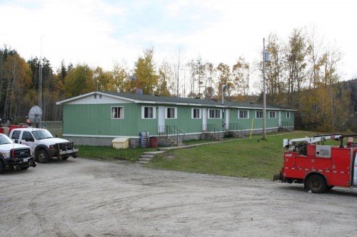
Parking lot behind the station, with a view down the main street in town. Note the corner of the structure at the extreme left, which is the modern crew bunkhouse at Hawk:
IMG_7562

Hawk Junction, October 1, 2013. Chris vanderHeide photo.

That pretty conclusively dates this structure’s existence at least to the late 1970s.
scan0009

Hawk Junction, winter 1980/81. Photographer unknown, Chris vanderHeide collection.

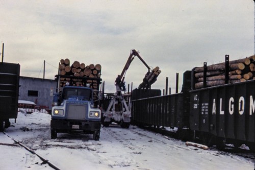
This was one of those photos that had me mystified as to its location at first, as the box of slides was completely jumbled and in random order. Once the slides were put in sequence and I realized this was smack in the middle of a large group of other slides all taken at Hawk Junction, it became clear as day.

This view shows gondolas being loaded with pulpwood on the old team track at Hawk Junction. The grey structure is the former freight shed and the track at left, also filled with gons on this day, is the shed track. Unfortunately there are very little photos of the Hawk freight shed available. The only other photo I’ve found so far is this 1984 photo online, taken from another cab ride on the ACR.

scan0018

Hawk Junction, winter 1980/81. Photographer unknown, Chris vanderHeide collection.
scan0011

Hawk Junction, winter 1980/81. Photographer unknown, Chris vanderHeide collection.

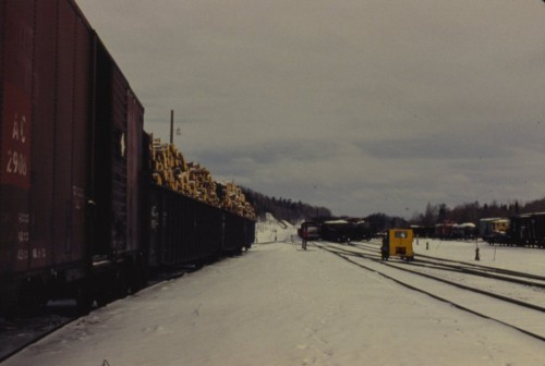
Looking northward at the actual junction switch at Hawk Junction. The cars at left are spotted in the shed track; this is basically the reverse view of the previous photo of the freight shed and pulpwood gondolas. The Michipicoten Subdivision rises away at dead centre. (Click on the photo to bring up the large size for a better view.)

Note how the Michipicoten sub diverges from the main line at the junction switch at exact centre of the image. (The first track to the right with cars on it is actually the Northern Subdivision main; a train, probably made up and prepared to head south, is currently blocking the main track.)

When I rode the passenger train at the beginning of October, I had a hard time reconciling the current track arrangement with my memory of photographs such as the above image and similar images mostly from the 1970s plus track maps and older aerial photos in some of the published books on the ACR.

IMG_7966

Hawk Junction, October 1, 2013. Chris vanderHeide photo.

First of all, when we closely compare this arrangement in the above photo to older photos and maps, it can’t be directly correlated. The older photos show a crossover to the main track, and then a ladder that branches to the right. In the above photo we see the ladder, but the (removed) switch to the abandoned track between the current main and the two remaining tracks doesn’t relate to the older track maps. Simply comparing to the track map, that entire track doesn’t seem to fit.
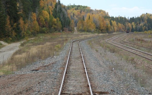
IMG_7963

Hawk Junction, October 1, 2013. Chris vanderHeide photo.

Here we can also see the abandoned Michipicoten Subdivision directly aligned with the current main line, while the 1980 photo above (and similar photos, and published maps and aerials) clearly shows that the branch should be offset to the left of the Northern sub. main. Note at foreground the removed switch to the team track and shed track.

It becomes pretty quickly clear that a rather significant track realignment has taken place here. It’s obvious that the main track has been realigned from the north end of the station platform to align with the Michipicoten sub, with the first several hundred feet of the former branch becoming a main track for the Northern subdivision, and the junction moved several hundred feet north. Where the yard curves to the right, the original Northern sub. main has been realigned to connect to the track that was formerly the Michipicoten sub main.

So, the current main (at least for the straight portion in the foreground of the above photo) is actually originally the first part of the Michipicoten branch, the first yard track (now torn out) is the old main track of the Northern sub. However there’s one more sticky point, and that’s that the old maps and photos show that the first track next to the old main was a drill track for the south yard, and connected to the main just beyond the curve, with the remaining yard tracks following the curve. So all of the yard tracks must also have been cut and realigned to different tracks beyond the curve. If the first portion of the Michipicoten sub is now the current main track, then the old portion of the main track was realigned to track 1. The drill track must have been realigned to connect to track 2, and the old track one realigned to track 3.

This map, showing before and after, shows how I believe things to have been re-aligned (click on the image for a larger version):

ac0010

Now, reference again that 1984 photo showing the freight shed mentioned above. The middle piece between the front windows just manages to not obscure the switch arrangement there, and we can see it matches the current arrangement. And this photo from the same set, taken roughly at the same location and angle as my last photo above (except from a locomotive cab instead of out the back door of the passenger coach), shows the new junction switch. If the slides are from the winter of 1980-81, and by the fall of 1984 the track arrangement is completely different, that pretty safely places the date of this rebuild to the very early 1980s. The track doesn’t necessarily look really fresh in that photo, so the work may have been done as early as the summer of 1981?

It kind of begs the question why such an expensive rebuild was done, and what value was actually realized by the new track arrangement, which doesn’t really seem like it would be all that different operationally. But, with my intended modeling timeframe being summer 1985, this certainly has a big impact on how I design my Hawk Junction yard someday – the published aerial photos and track map I’ve always used as reference actually don’t reflect the arrangment I should be using.

Since the closure of the iron mines and sinter plant at Wawa in 1998, Hawk Junction has been dying a slow death. As the Algoma Ore Properties operation was the only customer on the branch, abandonment was quickly applied for and granted in 2000. By 2001 the rails were ripped out and Hawk Junction was no longer truely a junction. Several yard tracks and the team track are gone, and the engine house is only used by MOW crews now. Daily freight trains still serve Hawk Junction, but it’s little more than a crew change point now, and traffic is a shadow of what it was.

Notes on an Old Slide Collection

Earlier this summer I acquired a small collection of ACR images from an individual in the states. The slides appear to have been primarily taken on the occasion of a railfan visit to the Algoma Central, and while of varying quality, contain some interesting content. The photographer appears to have gotten a cab ride (in a trailing unit) on both a northbound and southbound freight over the Soo subdivision, a caboose ride on an ore train on the Michipicoten branch and on the Northern sub (at least as far as Franz).
None of the slides were marked for location, date or photographer’s name, making identification a little interesting in some cases. However most of the slides had numbers written on the slide mounts allowing them to be put into proper sequence, at which point a story unfolded and certain views could this be related to each other. My own ride on the Tour of the Line at the beginning of October also helped to familiarize myself with the line and I could thus confirm a few of the location identities.

While the slides are undated, a few items have allowed me to date the images to the winter of 1980-81 with a pretty high degree of certainty. One image in the collection is of baggage car 211, which was renumbered 302 in the spring of 1981 with the arrival of the 200-205 series GP38-2 locomotives. Another image of the ACR’s scale test car clearly shows a 5-80 reweigh date on the car, which pretty nicely brackets the time frame of the images to a specific year.

The background thus identified, here follows a few selections of interest, in no particular order.

scan0015

Steelton, Winter 1980/81. Photographer unknown, Chris vanderHeide collection.

Scale house at Steelton yard. The ground level window on the rear of the structure seems an odd feature. In the background is the ACR’s sprawling Steelton yard and the Algoma Steel Corporation mill. Several AC freight cars including one of the ACR’s unique 61′ bulkhead gondolas, an even more unique curved side “bathtub” style hopper and a covered gondola for coil steel service are visible.

scan0017

Frater, Winter 1980/81. Photographer unknown, Chris vanderHeide collection.

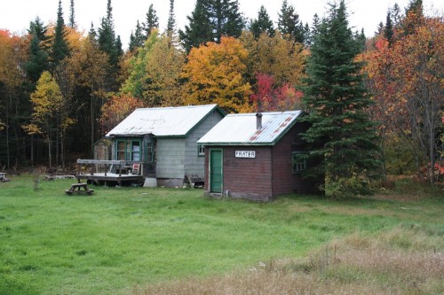
Frater station. In deep snow with snowmobile tracks all over. There are other better photos of the station building at Frater available online, but this nicely relates the station to the two small outbuildings behind. The station has long been torn down, but those two small structures still exist today. The grey structure appears to have been converted into a small cabin; note the new “bay window” added to the front of this structure, which appears to be salvaged material from the station.

IMG_7462

Frater, Sep 30, 2013. Chris vanderHeide photo.


scan0008

Frater siding, winter 1980/81. Photographer unknown, Chris vanderHeide collection.

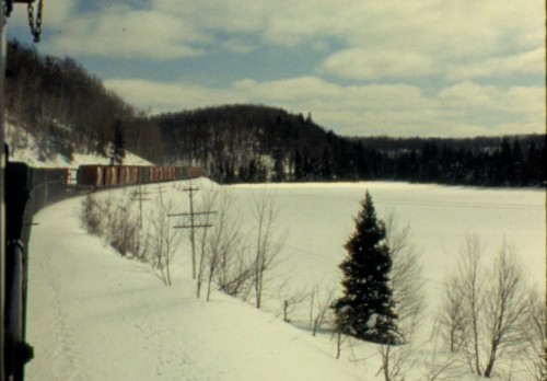
The location for the above photo would appear to also be at Frater, just south of the station, showing a northbound freight running along the shore of Frater Lake. Note the long string of CP 40′ boxcars in the train; at least a dozen can be counted before the train curves away. Likely these are empties heading back to Schreiber on the CPR for woodpulp loading. This is an interesting photo for highlighting the volume of this traffic over the ACR.

scan0014

Franz, winter 1980/81. Photographer unknown, Chris vanderHeide collection.

Crossing the CPR at Franz, riding in the caboose of a northbound freight. More CP 40′ boxcars are spotted in the interchange track; one is painted in green which signified newsprint service. All of the cars seen here are probably 8′ door cars (all the newsprint assigned cars were 8 footers) in service hauling woodpulp from mills along the Lake Superior north shore.

Speaking of Franz, here’s a look southward off the rear of that caboose:

scan0013

Franz, winter 1980/81. Photographer unknown, Chris vanderHeide collection.

All of the structures visible in the above photo, except for a small white speeder shed roughly in the centre of the photo, still stand today. The station at Franz was closed in 1992 with the end of train order operation on the ACR, and ended up being moved to the community of Dubreuilville.

scan0016

Perry pit, winter 1980/81. Photographer unknown, Chris vanderHeide collection.

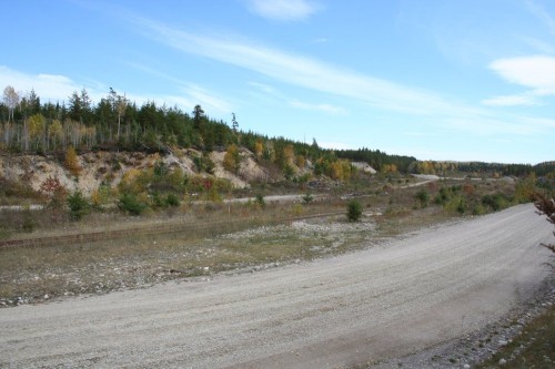
The above photo was tentatively identified as the ballast pit just north of Perry siding, based on the excavated appearance of the embankment in the background and its sequence number and relation to other images/locations. This was able to be conclusively confirmed when I rode the ACR passenger train on the last day of September and easily recognized the location.

The above images makes it a little unclear whether any ballast was still quaried from the gravel pit here during the 1980s, but interestingly there was clearly quite an active pulpwood loadout here during this time frame.

Perry pit today, the rails for the spur are still there, but the main track switch has been removed and the site is abandoned:

IMG_7536

Perry pit, September 30, 2013. Chris vanderHeide photo.

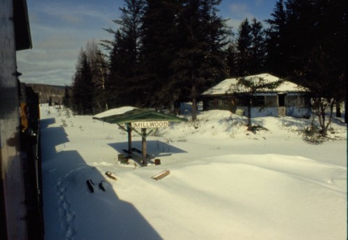
scan0007

Millwood, winter 1980/81. Photographer unknown, Chris vanderHeide collection.

A simple passenger shelter at Millwood (mile 212.9). Simple shelters like this were erected at several flag stop locations along the line.

That’s all for tonight, probably more to come periodically.