Additional Photos from Agawa Canyon Park

This follow-up to my post about my ride on the Agawa Canyon Tour Train last week contains several additional photos of items of interest around Agawa Canyon Park, in no real specific order.

IMG_0039

Canyon Lodge, near the north end of the park.

IMG_0040

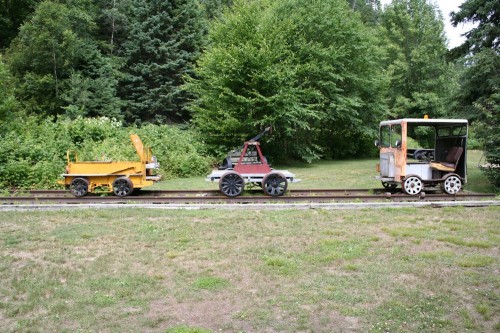
This display of track speeders and handcar is located near the north end of the park, across the tracks from the Canyon Lodge.

IMG_0042

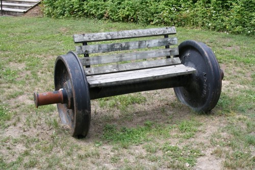
One of a pair of benches made out of an old wheelset. What an appropriate feature to have at a railway owned park. 😉

IMG_0045

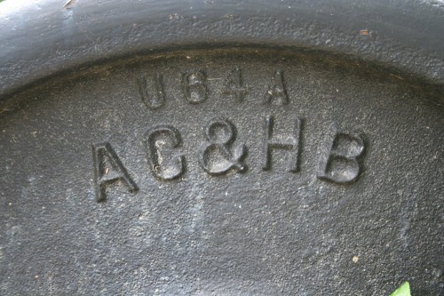
Cast lettering on the back of one of the wheels. AC&HB refers to the full name of the Algoma Central & Hudson Bay Railway, as the company was officially called until 1960. Having never extended anywhere close to Hudson Bay (while surveys were conducted during the initial 1899-1903 construction period, the railway finally reached Hearst in 1914 and was never extended beyond there) the “& Hudson Bay” part of the name was finally dropped.

IMG_0047

A picnic table made from an entire freight car truck. IIRC the sideframe had a 1928 date cast into it, so it may be originally from one of the Algoma Central’s 3100-3199 series wood boxcars, which were built in 1928.

IMG_0067

IMG_0090

The Agawa Canyon Park is only accessible by rail. There is no road access in or out of any kind. Therefore anything coming in or out of the park must go by rail. Garbage collection service for the park is handled by flatcars with dumpsters; trash is collected by the park staff from trash cans in the park and put into the dumpsters which will be hauled away at regular intervals by the regular freight.

IMG_0100

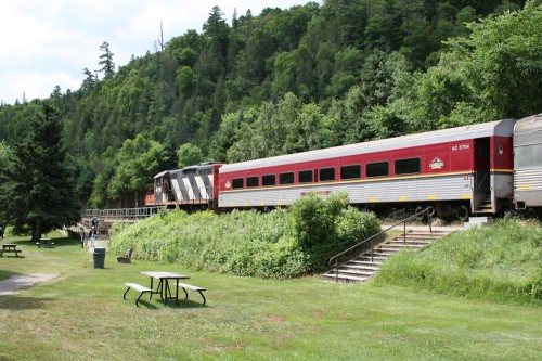
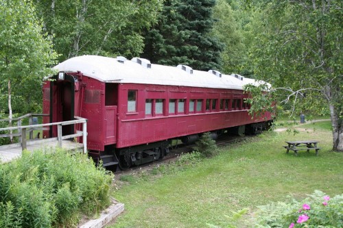
This old passenger car in the park was previously used as a souvenir shop on site, but appears to be unused now.

This car’s last official identity before retirement was as work service diner 10400, and was previously cafe car 502. It had been originally acquired by the Algoma Central in 1949 from the Denver & Rio Grande Western and were originally built for the Denver & Salt Lake Railroad in 1913.

IMG_0105

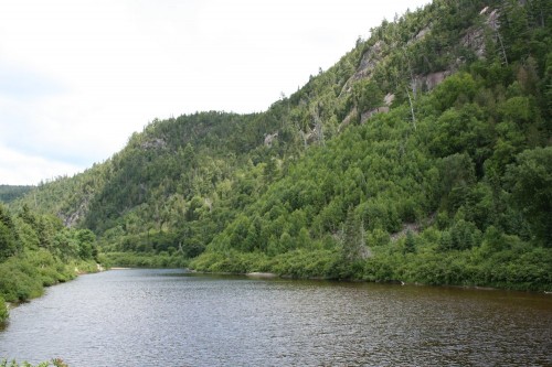
And one final shot of the serene Agawa River through the canyon.

Agawa Canyon Tour Train Ride

At the beginning of this week I just returned from another week long vacation north of Lake Huron, visting the former Algoma Central and the Huron Central and Ontario Northland railways.

Having previously ridden the Tour of the Line last October, on Monday July 28th, I had a ticket booked to ride the Agawa Canyon Tour Train. The tickets are booked over the phone (which the helpful ACR staff make quite easy – and it’s nice to hear them answer the phone as “Algoma Central Railway”) and can be picked up at the station the morning of the departure. The train’s scheduled departure is at 8 AM, and tickets can be picked up at the station half an hour before the train leaves. I think I arrived there a little before 7:30 and ended up beating the line. Eventually around 7:40 or so the train pulled into the station and we were able to board.

IMG_0154

The tour train at Sault Ste. Marie station. (This photo actually taken after the return to the Sault, when the sunlight is actually on the right side for photographs at this location.)

The train this day was a short 6 cars, including dining car 506, and one of the regular F40PHR locomotives was apparently away in Toronto for some repair work, so the engine on the south end of the train was a CN GP9Rm. The complete consist was as follows (from the north end):

CN 105 (F40PHR)
AC 5705 (Coach)
AC 5702 (Coach)
AC 5655 (Coach)
AC 5703 (Coach)
AC 506 (Dining Car)
AC 5704
CN 4110 (GP9Rm)

The train left precisely on time and we slowly rolled through the downtown, past the huge Essar Steel Algoma mill and past the sprawling CN yards and shops before finally clearing the yard limits and entering the main line north of town. Then it was off into the wilderness north of the Sault.

IMG_0023

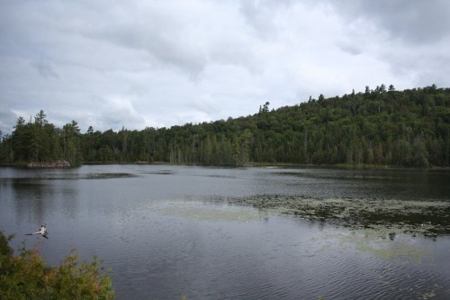
Typical lake view along the line.

Inside the coaches on the train there are video monitors throughout, which over the course of the trip play video commentary describing features of the line and its history. The video segments are apparently triggered by GPS location, so it tells you when certain notable features (like the Montreal Falls trestle for one particular example) are soon to be encountered, and also to spread out the history segments over the trip. While to an ACR historian like myself much of the information was known, I still found myself watching each segment when they played with interest, and it certainly gives an interesting background to the area you’re riding through. (Although a couple parts of the narration could use some updating as they refer to the St. Marys Paper Company as a current operation, while it has closed down a few years ago and the mill has been mostly demolished except for some of the remaining original sandstone structures dating from the 1890s mill.)

When the history segments weren’t showing on the monitors, the view was normally from a camera mounted in the front window of the lead F40PHR locomotive, giving a nice live view of the track ahead of the train. This was nice to see features ahead of the train, and was particularly interesting at one point where the train slowed because of a pair of large birds that when disturbed by the train simply flew along the tracks in front of the train for about a minute or so before finally gaining height and flying out of the way!

IMG_0124

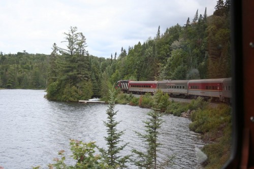
The train skirts the shore of another small northern Ontario lake.

About half an hour after departure from the Sault, the dining car opened for breakfast, for which they called the various coaches in turn. I had made sure I had something to eat at my room before heading down to the station, so I did not partake of breakfast, but later when the dining car switched over to serving lunch (for which the kitchen remained continuously open until a little after 4 PM) the on-board service staff took orders for boxed lunches from those who wished it, and these orders were taken far enough in advance of the arrival at Canyon so that you would be able to take your lunch and have a nice picnic within the park environs. I ended up ordering one of these lunches, which I believe was about $15 and contained a sandwich (on a nice large Kaiser bun, which could be one of three options: roast beef, tuna or ham & cheese – I chose the ham & cheese), bottle of water, bag of chips, brownie and a hard-boiled egg.

IMG_0056

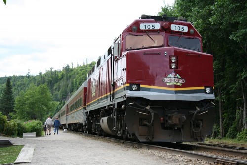
F40PHR 105 on the north end of the Agawa Canyon Tour Train at Agawa Canyon Park.

After arrival at Canyon, I wandered around the lower part of the park for a while, enjoying the area along the river, eating my lunch and taking a number of photos of the train in the park setting.

IMG_0074

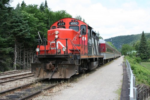
This CN GP9Rm was the southbound unit on the train. There are no turning facilities at Canyon, and the F40PHR has to remain connected to the train as it is also the on-board power source, so the tour train is operated with locomotives at each end.

IMG_0071

Looking south from the train at Canyon.

IMG_0088

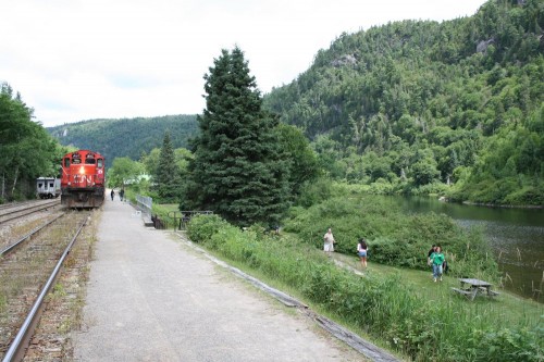
The tour train in its context at Agawa Canyon Park. The small car on the house track to the left of the train is the railway’s “camp car”, which car be rented for an overnight stay at the park.

IMG_0109

The rocky cliffs on the other side of the river from the train’s stopping location in the park.

Ultimately, the time in the canyon came to an end, and the whistle was blown giving the 5 minute warning to return to the train for departure. The northbound passenger train to Hearst was also running that day, and I had hoped to photograph it arriving at the south end of Canyon siding, unfortunately it did not end up arriving until after our train had reboarded, and we rolled slowly to the south switch to meet the regular train there, heading south as soon as it had cleared into the siding. So I was only able to see the train from the windows of my coach as it passed by on the adjacent track, and no photos. So that was my disappointment on the trip, from a railfan’s perspective, but the actual ride to and from the Canyon was relaxing and enjoyable, as I alternately read my book or watched the northern Ontario scenery with it’s unending forest dotted with rocky hills and myriad small lakes roll by outside.

Our return time to the Sault was approximately 5:30 PM, and with the sun now in the perfect position for taking photographs at the station, I photographed the train as the unboarding completed and the train pulled out of the station to head back to the yard for servicing, cleaning and overnight parking until the next day’s train. Once the train departed the station, I wandered past the Huron Central yard to photograph some of the pulpwood flatcars around there and then headed off to find some supper, a nice day of train riding completed.

Oba Lake-Franz Video

Here’s some timely video I came across on YouTube taken in 1994 from the southbound regular passenger train, starting from the longest (middle) of the three trestles at Oba Lake. Video begins with showing the train crossing the wooden trestles on Oba Lake at mile 212.7 and 211.9, then has a fair bit of running between Oba Lake and Franz, with several other small lakes and at least one siding (at Hilda or Scully) seen before arriving at Franz near the end of the video. The southbound approach signal is seen before arriving at the Franz diamond.

In the video, you can see that the long trestle at mile 212.7 was still the original wood trestle in 1994. This bridge was replaced by a trestle with steel pilings sometime in the late 1990s or early 2000s.

Here again is the modern trestle and widened approach alignment where you can see the track has been moved to the right:

IMG_7849

Oba Lake Trestles

While along its route the ACR runs alongside many lakes and rivers, just south of the station and siding at Mosher, the Algoma Central skirts the shores of Oba Lake, and here is found one of the more interesting features on the railway that is rarely photographed.

As the line hugs the shoreline of this large lake, it cuts directly across the mouths of several bays on a series of causeways and trestle bridges.

You can see the line cutting directly across these bodies of water in the satellite image below:
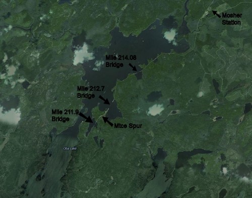
ObaLakeSatellite

While not as spectacular as the iconic 1550′ curving steel viaduct over the Montreal River and power dam at Montreal Falls, or even the 800′ long trestle at Bellevue, these bridges are an interesting feature, and the longest of these bridges is nearly 1200′ in length (not including the approach causeways) and mere feet above the surface of Hoodoo bay.

All three of these trestles were wooden pile-bent construction. (Although the longest bridge has since been upgraded, but more on that later.)

According to the stories, when these bridges were first built across these bays, the ACR engineers found themselves driving piles into nearly “bottomless” mud and muskeg, and the bridge piles apparently “float”, held up by the friction of the pilings in the mud rather than any solid foundation. All trains cross these bridges at a severely restricted speed of 20 MPH, and the conductor on our train when I rode the line in October mentioned that if one were actually standing trackside when a train passes, you can actually visually see the bridge deflect by at least 6 inches!

ObaLakeChart

This excerpt from a 1996 Wisconsin Central track chart shows the area of the three bridges, located at mileage 211.9, 212.4 and 214.2 respectively. Lines at the top of the chart indicate the curvature and grade of the line. The railway is shown as a straight line with marks and notations indicating the location and length of each bridge and culvert, as well as the details of their construction.

For example, the first trestle has the following notation above the mark indicating its location:

211.90   31 SP PB
424′ LONG

The “211.90” is the mileage of the bridge. The “424′ LONG” is obviously pretty self-explanatory. The “31 SP PB” is a little more cryptic, but this indicates the construction of the bridge: a 31 span (SP) pile-bent (PB) trestle.

You can see the notations along the bottom of the chart indicating the speed limits for this section of the railway, note the 20 MPH limit for all trains over the bridges.

Mile 211.90 Bridge

IMG_7870

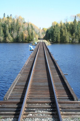
The first trestle is the 424′ long wooden pile trestle at Mile 211.90.
IMG_7868

Note the lack of guard rails on this trestle, which you’ll also see on the other wooden bridge at Mile 214.08.

IMG_7865

Milepost 212 is located on the approach causeway just north of the end of the actual trestle.

IMG_7862

At the north end of the causeway is a stop for Woods Camp, one of many such remote wilderness camps along the ACR. In addition to this small shed, just down and to the left out of frame is a small floating boat dock (the actual camp is located somewhere else on Oba Lake and accessed via water).

Mile 212.4 Spur

Between the first and second bridges is this short little maintenance spur for storing supplies and work equipment when maintenance is being performed on these trestles (this is a very remote area).

IMG_7855

This isn’t shown on the track chart above, but is listed in old timetables from as a 7-car company spur, and is clearly still in place today (as shown in these 2013 photos).

All around this area were stored fresh timbers and supplies for maintaining the wooden bridges, plus a couple of big piles of ruined ties that have been removed and replaced on nearby track.
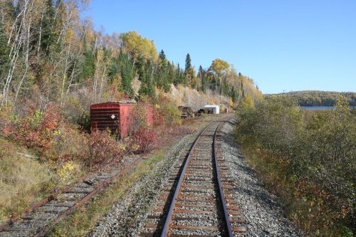
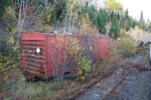
In the weeds at the south end of the spur is an old ex-Ontario Northland boxcar used for a storage shed.
Mile 212.70 Bridge

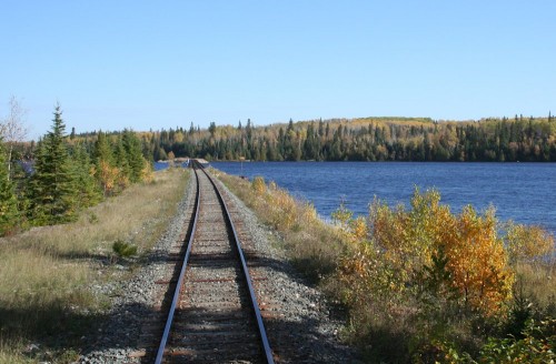
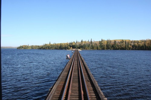
At nearly 1200′ in length not including the approach causeways at either end, this is the longest of the three bridges at Oba Lake. At some point in time, this bridge has been replaced with a new bridge with steel pilings with concrete caps supporting the bridge spans.

The original bridge would have looked identical to the other two, other than the much greater length.
IMG_7851

The southern approach to the bridge, looking north with Hoodoo Bay to the right. Note the obvious widening of the roadbed to the left for the original alignment of the old bridge.

When crossing over the bridge, the wooden pilings for the original bridge can be seen on the left side, although the water level in the lake was high when I travelled in October, so the tops of the pilings were just below the surface of the water and are not visible in any of my photos. They were quite visible in person however, and I’ve seen other photos where the water level is lower and the tops of the pilings do stick up above the surface.
IMG_7847

This photo is taken roughly at the mid-point of the bridge.

With the upgraded bridge, the train was able to travel a bit faster than the 20 MPH restriction on the other two entirely wooden bridges.

IMG_7845

IMG_7633

Detail of the abutment at the end of the bridge.

You can just see the ends of the concrete caps on the pilings which support the new bridge spans.

The horizontal timber at the water’s surface is evidence of the original wooden bridge.

IMG_7844

Again note the widened causeway on the north end of the bridge. The original alignment would have been to the left.

Mile 214.20 Bridge

IMG_7838

And lastly, the third bridge at Oba Lake is this 445′ bridge at mile 214.2. The construction is again identical to the first.

IMG_7836

The bridge at Mile 214.2, with the track curving away on the causeway on the north end to run along the shoreline.
IMG_7833

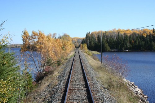
Just under a mile north of the last bridge is one final causeway that completely cuts off another small bay of Oba Lake. This is also clearly visible on the satellite image at the top of this post.

While it would certainly not be feasible to model all three of these bridges, and certainly not to full scale (the longest bridge would be over 13 1/2 feet long in HO scale just for the bridge, not including the approach causeways and even the two shorter bridges would be at least 5 feet long) I’d definitely like to include a representation of at least one of these bridges south of Mosher on my eventual layout, as I think the long, low trestle running just 10 feet above the surface of a quiet lake will make a great model scene.

Classic Algoma Central on YouTube

One of the great things about the modern internet is the massive amount of free user-posted content, whether on personal sites or blogs like this one, various archive and gallery sites of user-submitted content like RailPictures, or the big photo and video archive sites like flickr and YouTube. Of course you sometimes have to wade through material that’s less than useful in some cases, but there’s a lot of pure gold out there to be found if you spend enough time looking.

Here’s a couple of video selections from YouTube’s archive that nicely highlight a few aspects of operations on the ACR before the WC takeover, mostly from the early 1990s.

Classic compilation 1988-1994

Nice compilation of video from several visits to the ACR in the late 1980s and early 1990s.

The first part of video features mostly shots of the passenger trains, both the Agawa Canyon Tour Train and the regular train to Hearst along the highway between Sault Ste. Marie and Searchmont. Note in particular one sequence of clips during the fall season where the regular train is expanded and equipped with coaches leased from Ontario Northland. During peak periods, the ACR’s entire coach roster would be pressed into service on the Agawa Canyon Tour Train, and extra coaches would be rented from Ontario Northland and VIA Rail to fill out the regular passenger service. At such times also, with the Tour Train running at full capacity the regular passenger train would basically be operating like a second section of the tour train – extra coaches would be dropped off at Canyon, and lifted by the southbound regular train, which would also run 30 minutes after its normal schedule to allow the overflow Canyon passengers more time in the park.

The last couple minutes of the video also feature some nice freight operation at Hawk Junction yard and Michipicoten harbour and the northbound regular passenger train with a borrowed CP track evaluation train set tacked on the end.

Southbound train no. 10 out of Hawk Junction in September 1994

A nice big southbound freight leaving Hawk Junction. Note several cars of lumber from Dubreuil Forest Products (including one of the 60′ woodchip gondolas rebuilt as a unique looking lumber hauling car), LOTS of pulpwood loads, and some assorted traffic near the rear including some other lumber loads (from CN interchange at Hearst?) and flatcars and gondolas for steel loading.

Northbound train no. 5 out of Hawk Junction in September 1994

Mostly interchange traffic in the form of empty CP boxcars in woodpulp service and steel loads are visible in this clip.